Guest Blog: Former pipeline inspector raises serious questions about the effectiveness of the current regulatory system

The author previously worked as a state pipeline inspector, working in conjunction with the Federal Pipeline and Hazardous Materials Safety Agency (PHMSA). The author requested anonymity.

I became a state pipeline inspector to protect the public. Inspectors are charged with inspecting each oil, gas and ammonia pipeline in the state for compliance with the federal codes on such things as pipeline construction, operations, maintenance and public awareness.

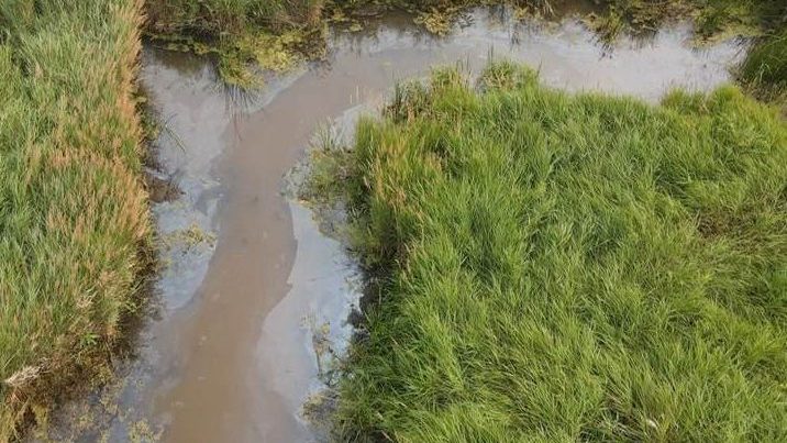
Each time an accident occurs – whether it results in small environmental harm or a death – new regulations are written to prevent that failure in the future.

Continue reading “Guest Blog: Former pipeline inspector raises serious questions about the effectiveness of the current regulatory system”

Anishinaabe photographer uncovers continuing frac-out damage near the Mississippi Headwaters

When we talk about a frac-out, it’s easy to think of it as a one-time event. The spill happens and (hopefully) gets cleaned up.

But on Sept. 17, Ron Turney of the Indigenous Environmental Network captured footage that shows much more going on beneath the surface. Near Camp Firelight seven miles from the Mississippi Headwaters, there is evidence of frac-out damage not previously seen, now that Enbridge has removed it temporary plank road.

Continue reading “Anishinaabe photographer uncovers continuing frac-out damage near the Mississippi Headwaters”

Mapping the Enbridge Line 3 frac outs

A Watch the Line volunteer put together a map showing all the places that Enbridge Line 3 has had frac-outs. Enbridge is drilling under 21 waters and wetlands using a technique called horizontal directional drilling. The process requires drilling mud to lubricate and cool the drill. The process happens under pressure and the drilling mud can get forced into cracks in the subsurface soils and get pushed to the surface, showing up in on land or in waterways.

The following summarizes all of the frac-outs.

Continue reading “Mapping the Enbridge Line 3 frac outs”

Enbridge has to decontaminate water it polluted decades ago in order to use it for Line 3 dewatering

Enbridge’s controversial plans to increase dewatering during Line 3 construction got an added complication: Workers need to dewater in areas where the company had past crude oil spills, leaving 8,400 gallons in ground for decades.

That means Enbridge has to treat the dewatered polluted water before returning it to the environment.

Continue reading “Enbridge has to decontaminate water it polluted decades ago in order to use it for Line 3 dewatering”

MPCA: Enbridge Polluted Water at 63% of Horizontal Drilling Locations

Mississippi River pollution, as reported by water protectors following conclusion of horizontal drilling near the headwaters

In a pair of Aug. 9 tweets, the Minnesota Pollution Control Agency (MPCA) shared its summary of the harm caused (so far) by Enbridge as crews drilled beneath our waterways to construct the Line 3 tar sands oil pipeline. Below, we offer some context for these numbers, and why Minnesotans should be alarmed.

Continue reading “MPCA: Enbridge Polluted Water at 63% of Horizontal Drilling Locations”

Focusing on Horizontal Directional Drilling

Daggett Brook (Cass County), one of the waterways threatened by horizontal drilling (as photographed by a Watch the Line volunteer monitor)

As we’ve previously written, of the more than 200 waterways that Line 3 will have to cross through northern Minnesota, Enbridge will be tunneling underneath 21 of them using a process called Horizontal Directional Drilling (HDD).

As there has already been one documented frac-out at the Willow River HDD crossing (July 6), it is critical that we keep our eyes on these locations. Below, we have compiled some resources–including a new training video–to prepare volunteers for monitoring HDD locations.

Continue reading “Focusing on Horizontal Directional Drilling”

Heavy weights used to hold Line 3 pipeline down in wetlands

Line 3 construction site in Aitkin County, east of Highway 65.

Enbridge Line 3 construction is damaging wetlands. The proposed route is crossing 78 miles of wetlands, or one fifth of its entire route. Workers often install temporary plank roads in and around wetlands to support heavy equipment.

Line 3 is crossing different types of wetlands: emergent, unconsolidated bottom, scrub-shrub, and forested wetland, Enbridge says. One challenge in trenching a pipeline through a wetland is that pipelines can float. Workers have to put weights on them to get them to sink and stay down.

When you are monitoring Line 3 construction, you might see some large black bags near construction sites. These are bags filled with local aggregate to sink the pipeline in place. The industry term is “buoyancy control.”

In water saturated wetlands, one crossing method is called the “push-pull.” Workers excavate a trench working from the plank road, float the assembled pipeline, put weights on it, then push and pull it to get it to sink.

Horizontal Directional Drilling also is used to cross wetlands. Click here for Enbridge’s summary of wetland crossing methods.

Enbridge diagram of a wetland crossing.

Enbridge Line 3 harms state forests, Wildlife Management Areas

Watch the Line monitors recently saw pipeline staged through Savanna State Forest, a couple miles east of Highway 65.

Line 3’s approved route crosses approximately 41 miles of public/municipal land in Cass, Crow Wing, and Aitkin counties, according to the state’s Environmental Impact Statement (EIS). Most of this land is state forest land administered by Minnesota Department of Natural Resources (DNR). More than 10 percent of Line 3’s route crosses public lands.

Continue reading “Enbridge Line 3 harms state forests, Wildlife Management Areas”

Tutorial: Using the Watch the Line Map

Watch the Line Project Map

Watch the Line’s project map depicts the road and water crossings along the Line 3 route, and can be a valuable resource for volunteers and the general public:

  • Watch the Line volunteer monitors can reference the map before and during a monitoring trip to become familiar with their surroundings and navigate between observation sites.
  • Anyone who wants to learn more about Line 3 can reference our map to better understand where construction is happening and its proximity to critical water resources and habitats.

We have created a video tutorial which goes over the key map features.

Continue reading “Tutorial: Using the Watch the Line Map”

DNR allows Enbridge to draw more groundwater

In January, Enbridge realized that it had vastly underestimated the amount of water needed for temporary trench dewatering during construction.

Dewatering is necessary when constructing a pipeline through wet areas. Excess water must be drawn out from the trench to protect workers and stabilize the soil. The water is later discharged back into the ecosystem. The appropriation of groundwater for dewatering requires a DNR (Minnesota Department of Natural Resources) permit.

Continue reading “DNR allows Enbridge to draw more groundwater”